Difference Between Azimuth and Elevation
What is Azimuth?
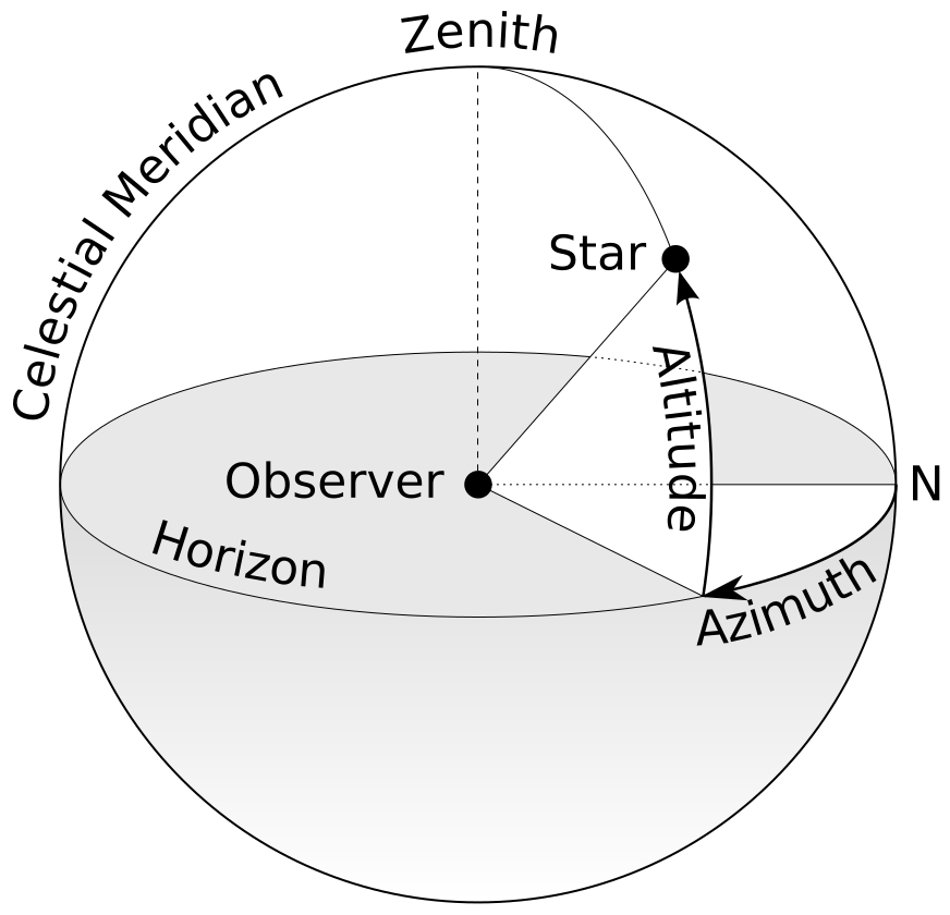
Azimuth is used in astronomy, navigation, geology, and other fields to measure the position of an object on the horizon or in reference to the horizon. Azimuth is measured east from due north. In astronomy, azimuth is often used in conjunction with altitude, which is the measure of the vertical position of an object, such as a star or planet, above the horizon.
Azimuth is measured in degrees where the horizon is a horizontal 360° circle. In the modern system, due north is 0° while due east is 90°, due south is 180°, and due west is 270°. The term azimuth is derived from the Arabic term, al samt, which referred to the direction of a celestial object measured along the horizon in Medieval Islamic astronomy. The modern term is specifically derived from the plural form of the word: al summut.
One notable difference between the modern azimuth system and the one used in Medieval Islamic astronomy is that Islamic astronomers tended to measure azimuth from the east-west line, whereas azimuth is measured from due north today. The reason that azimuth is measured using a 0-360° interval may be related to the fact that many ancient calendars had 360 days and the stars appeared to move about 1 degree per day around the north star.
In addition to astronomy, azimuth is also used in fields like navigation and geology. For example, it is important for geology because geologists must determine the spatial orientation of the geologic units which they survey. For instance, when determining the orientation of a tilted sedimentary bed, geologists need to determine the strike angle. The strike angle is the azimuth of a horizontal line that is usually perpendicular to the direction in which a sedimentary bed is tilted, or the dip direction. The strike angle, along with the dip angle, is important in mapping and interpreting geologic structures.
What is Elevation?
In geography and earth sciences, elevation is a measurement of the vertical distance of a point above sea level. Sea level provides a convenient surface that is essentially, though not always, uniform across the planet, allowing distances to be reliably measured regardless of location. Other planets which do not have open bodies of water have different base levels from which to measure topography. On Mars, for example, an imaginary sphere called the areoid is used as the equivalent of sea level on Earth. The center of the areoid is at the center of Mars and the areoid has a radius of 3396 km.
Elevation data points are commonly used to make contour maps. A contour line is a line through multiple points that have the same value. For example, in an elevation map, someone would draw a line through all the points that were 10 m and another line through all the points that were 20 m. In addition to connecting points of the same value, the contour lines must also be of equal intervals on the same map. A contour line map where the contour interval is 10 m will have contour line values of 10 m, 20 m, 30 m, etc. The interval between the contour lines represents differences in elevation. Thus, a point that is between 10 m and 20 m contour lines will be a point that is between 10 m and 20 m above sea level. Contour maps are useful for determining the lay of the land, such as determining which points are in valleys and which points are on hills.
Elevation has a significant influence on climate. For example, high elevation areas tend to be colder than areas of lower elevation. Most of the human population on Earth lives within 150 m or less of sea level. The highest elevation at which humans live is the Tibetan plateau at an elevation of about 5330 m. Humans are not able to live at elevations much higher, since, above this threshold, the temperatures become too cold for farming and the oxygen levels in the atmosphere are too low for human life.
Notable elevations on Earth’s surface include the top of Mount Everest at 8849 m in elevation. The lowest land elevation point on Earth is at the shores of the Dead Sea which are 420 m below sea level.
The highest point in the solar system is Olympus Mons, a shield volcano on Mars with a height of 26,000 m. Another famous high point in the solar system is an equatorial ridge or mountain range on Saturn’s moon Iapetus. The ridge runs directly along the equator for over three quarters of the moon’s circumference and is about 20,000 m in height.
Similarities between Azimuth and Elevation
Azimuth and elevation are both used to measure the spatial position of a datapoint. They are also both used to create maps and are relevant for fields like geology and navigation.
Differences between Azimuth and Elevation
Although there are similarities between azimuth and elevation, there are also important differences. These differences include the following.
- Azimuth is measured in degrees, whereas elevation is usually measured in feet or meters.
- Azimuth measures the position of a point along a horizon, whereas elevation measures the distance of a point above sea level or an equivalent datum on a planetary surface.
- The reference points used in azimuth could be the same for other planets, whereas the reference datum for elevation (e.g., sea level) will differ from planet to planet.
- Azimuth ranges from 0 to 360 in numerical value, whereas elevation can theoretically take on any value.
Illuviation vs. Eluviation
Summary
Azimuth is a measurement of the position of an object along the horizon measured clockwise, or east-ward, from due north. Azimuth is measured in degrees and the word comes from a Medieval Arabic term which referred to roughly the same concept. Azimuth is used in a variety of fields including astronomy, geology, and navigation. Elevation is the vertical distance of a point above sea level. A datum equivalent to sea level is used on other planets which do not have oceans or open bodies of water to form a convenient base level. The possible maximum and minimum elevation depends on the planet on which you live. The highest mountain on Earth is only 8849 m in elevation, whereas on Mars, there are volcanoes that are 26,000 meters in height. Azimuth and elevation are similar in that they are both used to measure the position of a point in space. They differ in important ways as well. Azimuth is measured in degrees, is measured from due north, has reference points that do not change from planet to planet, and has a numerical range of 0-360. Elevation is measured in linear units, usually feet or meters, is measured vertically from sea level, has reference points that would change depending on the planet where the measurements are being carried out, and has a measurement range that can theoretically take on any numerical value.
- Difference Between Environmental Performance Index and Development - November 24, 2023
- Difference Between Environmental Intervention and Development - November 8, 2023
- Difference Between Eco Efficiency and Eco Effectiveness - September 18, 2023
Search DifferenceBetween.net :
Leave a Response
References :
[0]Betz, Eric. “Olympus Mons: Mars’ mega volcano.” Astronomy, 3 Nov. 2020, https://astronomy.com/news/2020/11/olympus-mons-mars-mega-volcano. Accessed 13 May 2021.
[1]Hill, M.H. “Elevation.” Jackson State University Distance Learning, http://www.jsu.edu/depart/geography/mhill/phylabtwo/lab6/elevf.html. Accessed 13 May 2021.
[2]King, D.A. ‘Al-Samt’. Encyclopaedia of Islam, Second Edition. Ed. P. Bearman et al. Brill Reference Online. Web. 13 May 2021. https://referenceworks.brillonline.com/entries/encyclopaedia-of-islam-2/al-samt-SIM_6591.
[3]King, Hobart M. “Highest and Lowest Points on Mars.” Geology.com, https://geology.com/articles/highest-point-on-mars.shtml. Accessed 13 May 2021.
[4]Lakdawalla, Emily. “Iapetus’ peerless equatorial ridge.” The Planetary Society, https://www.planetary.org/articles/3389. Accessed 13 May 2021.
[5]Noyce, Wilfrid , Hunt, (Henry Cecil) John , Tenzing, Norgay , Bishop, Barry C. and Venables, Stephen. "Mount Everest". Encyclopedia Britannica, 13 May. 2021, https://www.britannica.com/place/Mount-Everest. Accessed 18 May 2021.
[6]“Sea Level.” National Geographic Resource Library, n.d., https://www.nationalgeographic.org/encyclopedia
[7]“Structural Geology Laboratory.” Southalabama.edu, n.d., https://www.southalabama.edu/geography/allison/GY403/StructuralLaboratory_3Dblock.pdf
[8]Zielinsky, Sarah. “The Tallest Mountains in the Solar System.” Smithsonian Magazine, 9 Jan. 2012, https://www.smithsonianmag.com/science-nature/the-tallest-mountains-in-the-solar-system-16525451/. Accessed 18 May 2021.
[9]Image credit: https://cdn4.picryl.com/photo/2019/09/14/drawings-of-eastwoods-big-bear-valley-dam-including-a-plan-an-elevation-and-aa1363-1024.jpg
[10]Image credit: https://commons.wikimedia.org/wiki/File:Azimuth-Altitude_schematic.svg