Difference Between Badlands and Black Hills
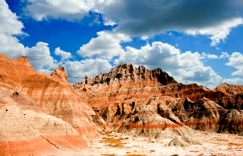
Badlands
The term, badlands, refers both to a type of geologic terrain and to a specific location in South Dakota marked by badlands terrain. Geologically, badlands terrain consists of soft sedimentary rock which has been eroded to create numerous canyons, buttes, and gullies. Badlands terrain typically occurs in semi-arid climates where there is little vegetation and torrential rains during part of the year.
“Badlands” is also a geographic term referring to territory in southwestern South Dakota characterized by badlands terrain. Badlands terrain is also found in U.S. states like Wyoming, Utah, and North Dakota. Globally, badlands areas are found in countries including Canada, Spain, Argentina, Italy, and New Zealand.
In some ways, badlands terrains resemble miniature versions of the terrain of mountainous desert regions in places like the southwestern United States, having many of the same formations but on a smaller scale.
Are the Badlands in the Black Hills?
The Badlands of South Dakota are east of the Black Hills and considered a separate geographic area. The Badlands are in their own park in South Dakota, Badlands National Park.
Geology of the South Dakota Badlands
The Badlands of South Dakota consist of eroded shale, sandstone, mudstone, and claystone among other sedimentary rock types. There is also volcanic ash. Five formations make up the South Dakota Badlands, the Pierre Shale, the Yellow Mounds, the Chadron Formation, the Brule Formation, and the Sharps Formation. Together, these formations represent about 75 million years of geologic history.
Pierre Shale
The Pierre Shale was deposited about 75-69 million years ago. It represents a shallow interior seaway that existed in North America in the late Cretaceous. The fossils found in this bed include cephalopods, such as ammonites, and marine reptiles, such as mosasaurs.
Yellow Mounds
Towards the end of the Cretaceous, the inland sea in western North America drained into the ancestral Arctic Ocean. After the inland sea drained, the shale layers became weathered and were transformed into soils. This formation appears yellowish, due to the presence of the mineral goethite. The Yellow Mounds represent a paleosol, a fossil soil.
Chadron Formation
Around 37 million years ago, clays began to be deposited over the weathered shale in a marshland environment. From 37 million years ago to 34 million years ago, this part of South Dakota would have resembled the everglades, hot and wet. It was inhabited by ancient relatives of modern allegators and by the rhinoceros-like brontotheres. This time-period is recorded in the claystone layers of the Chadron Formation.
Brule Formation
Around 34 million years ago, the swamps that formed the Chadron formation gave way to a drier savannah-like environment. The fossils in this formation show that the savannah was inhabited by oreodonts, ancient artiodactyls, a group that includes modern bison and bighorn sheep. There were also predators such as the nimravids, a clade of ancient cat-like carnivores. This time-period is preserved in the rocks of the Brule Formation.
Sharps Formation
The youngest and uppermost formation of the South Dakota Badlands is the Sharps Formation which represents a period of time from 30 million years ago to about 28 million years ago. The Base of the Sharps Formation contains a layer of volcanic ash, or a tuff, likely from eruptions that occurred in modern-day Nevada and Utah. It is characterized by sandstone from ancient river channels.
Formation of the South Dakota Badlands
The terrain that defines the modern South Dakota Badlands began to form around 500,000 years ago when the Cheyenne and White Rivers began to flow through the area, eroding into millions of years’ worth of built-up sediment. The South Dakota Badlands are eroding at about 1 inch per year. They are expected by geologists to erode completely within the next 500,000 years.
Are the Badlands worth seeing?
Yes, the South Dakota Badlands represent 75 million years of geologic history and are rich in fossils which reveal the natural history of ecosystems in the region. A trip to the Badlands is an educational opportunity.
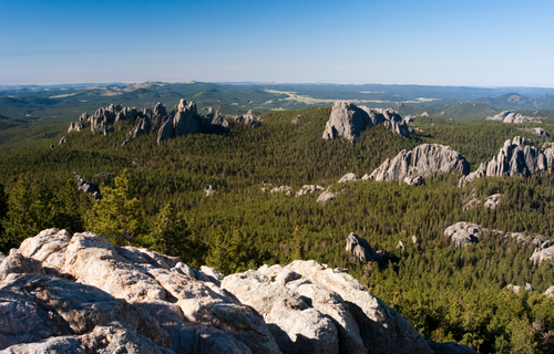
Black Hills
The Black Hills are an eroded mountain range in western South Dakota and northeastern Wyoming. The Black Hills are known for tourist attractions including the Jewel Cave National Monument, Custer State Park, and Mount Rushmore. The Black Hills also contain the highest peak in South Dakota, Black Elk Peak, at 2,207 meters or 7,242 ft. in height. The Black Hills are situated between the Cheyenne and Belle Fourche Rivers.
Geology of the Black Hills
The Black Hills consist of eroded granite peaks and metamorphic rock units to the south and evidence of volcanic activity to the north. The Black Hills were formed over 40 million years ago from the uplifting of granitic intrusive rock. This was accompanied by surface volcanism. The Black Hills are rich in minerals, such as quartz and feldspar. The region also contains important metals, including gold and uranium.
Ecology of the Black Hills
The Black Hills region is heavily forested, but also contains abundant prairies. One of the iconic animals of the Black Hills is the bison.
History of the Black Hills
The Native American groups that traditionally lived within or near the Black Hills include the Sioux, Cheyenne, Arapaho, and Kiowa, all of whom considered at least parts of the Black Hills to be sacred. Originally, the Sioux and the Arapaho were granted rights to the region at the Second Treaty of Fort Laramie in 1868. In 1874, however, gold was discovered in the Black Hills, leading to a goldrush and increased interest in the land from White Settlers. The treaty was not honored, and the Black Hills War ensued, culminating in the Battle of Little Bighorn in 1876. In 1877, the Sioux were forced to give up their rights to the Black Hills. After this, the Black Hills became known for its important gold mines, including the Homestake Mine.
How did the Black Hills get their name?
The forested slopes, rounded hilltops, and deep valleys of the region give it a dark appearance from a distance, leading to its name.
Similarities between Badlands and Black Hills
Are they the same thing?
The Black Hills and the South Dakota Badlands are both geologically important regions in western and southwestern South Dakota known to attract significant tourists. They are, however, not the same thing. They are separate geographic regions and geologic provinces.
Differences between Badlands and Black Hills
Although there are similarities between the Badlands and the Black Hills, there are also important differences. These include the following.
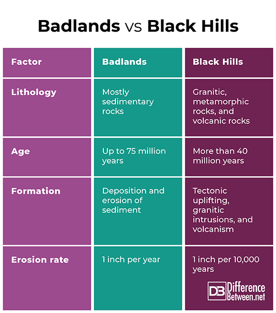
- The Badlands are principally composed of sedimentary rocks such as shale and claystone, whereas the Black Hills are composed of granite, metamorphic rocks, and volcanic rocks.
- The Badlands record 75 million years of history, whereas the Black Hills are at least 40 million years old.
- The Badlands were formed by millions of years of sedimentary erosion and deposition, whereas the Black Hills were formed by tectonic uplifting, granite intrusions, and volcanism.
- The Badlands are eroding at about in 1 inch per year, whereas the Black Hills are eroding at about 1 inch per 10,000 years.
Badlands vs. Black Hills
Summary
The term “badlands” can refer either to a type of geologic terrain defined by canyons, buttes, and gullies eroded into soft sedimentary rock or to a specific region in southwestern South Dakota within Badlands National Park. Badlands terrain is formed where the climate is dry, where vegetation is sparse, and where torrential rains occur part of the year. Badlands terrain can be thought of as a miniature version of mountainous desert terrain, such as terrain encountered in the southwestern United States. The Badlands of South Dakota represent 75 million years of deposition and erosion of sediment in environments that include shallow seas, marshlands, and savannah grasslands. The Black Hills are an eroded mountain range in southwestern South Dakota consisting of granitic and metamorphic rock formations with evidence of volcanic activity as well. The Black Hills were formed more than 40 million years ago due to tectonic uplifting related to a mountain building event. The Black Hills are also the location of significant events in the history of the United States and Native American nations, including the Black Hills War and the Battle of Little Bighorn in 1876. The South Dakota Badlands and the Black Hills are similar in that they are both in western and southwestern South Dakota and both have interesting geology which reveals important details about the geologic history of North America. They also attract significant numbers of tourists for the state of South Dakota. They differ in that the Badlands are composed mainly of sedimentary rock, have an age of up to 75 million years, formed from continuous deposition and erosion of sediment, and erode at a rate of about 1 inch per year, whereas the rocks of the Black Hills are primarily granitic, metamorphic, and volcanic, older than 40 million years in age, formed by tectonic uplifting, and erode at a rate of 1 inch per 10,000 years.
- Difference Between Environmental Performance Index and Development - November 24, 2023
- Difference Between Environmental Intervention and Development - November 8, 2023
- Difference Between Eco Efficiency and Eco Effectiveness - September 18, 2023
Search DifferenceBetween.net :
References :
[0]“Brontotheriidae.” American Museum of Natural History, n.d., https://research.amnh.org/paleontology/perissodactyl/evolution/groups/brontotheriidae.
[1]“Geological Resources (The Black Hills).” USDA Forest Service, n.d., https://www.fs.usda.gov/detail/blackhills/learning/nature-science/?cid=stelprdb5063013.
[2]“Geological Formations: How Badlands Buttes Came to Be.” National Park Service, 19 Nov. 2020, https://www.nps.gov/articles/000/badl-geologic-formations.htm.
[3]“Geology and Physiography of the Black Hills.” Integrating Research and Education, n.d., https://serc.carleton.edu/research_education/nativelands/pineridge/geology1.html.
[4]“Oreodont: Ancient Grazer of the Badlands.” National Park Service, 10 Nov. 2020, https://www.nps.gov/articles/000/oreodont.htm.
[5]Smith, Kenneth G. "Erosional processes and landforms in badlands national monument, South Dakota." Geological Society of America Bulletin 69.8 (1958): 975-1008.