Difference Between Geostationary and Low Earth Orbit Satellites
Over the past few decades, satellite communications have brought about a remarkable transformation in the field of space technology. With the advent of technological advancements, telecommunication systems have made it possible to communicate with virtually anyone at any time. Satellites have created a worldwide web of communication, ensuring that people from diverse corners of the Earth can connect effortlessly.
That being said, there are two main types of satellites: geostationary and low earth orbit (LEO) satellites. They allow for real-time data transmission, enabling instant access to information, whether it’s for weather forecasts, navigation, or live television broadcasts. In this article, we’ll discuss some key differences between geostationary and low earth orbit satellites.
What is a Geostationary Satellite?
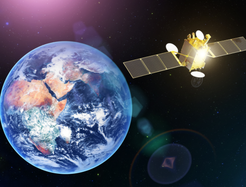
Geostationary satellites, often referred to as GEO satellites, are a specific type of high-altitude artificial satellite that holds a unique and valuable position in space. These satellites orbit the Earth at an altitude of approximately 22,236 miles (35,786 kilometers) above the equator. What makes them special is that they orbit the planet at the same rate that the Earth rotates, allowing them to remain in a fixed position relative to the Earth’s surface.
GEO satellites provide consistent coverage of a specific region on Earth. They are often used for broadcasting, telecommunications, and weather monitoring. Since they remain stationary above a specific region, geostationary satellites offer low-latency communication. Some popular geostationary satellites include NOAA’s GOES, Intelsat, Eutelstat, Morelos 3, and more.
What is a Low Earth Orbit Satellite?
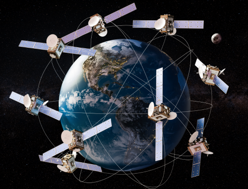
A low earth orbit (LEO) satellite, as the name suggests, is a kind of artificial satellite that orbits the Earth at relatively low altitudes compared to geostationary satellites. LEO satellites are typically positioned at altitudes ranging from about 160 miles (260 kilometers) to 1,200 miles (2,000 kilometers) above the Earth’s surface. One of the best examples of a low earth satellite is the Hubble space telescope.
Due to their lower altitude, LEO satellites move faster relative to the Earth’s surface. This results in shorter communication latency and quicker data transmission. They have a shorter operational lifespan compared to geostationary satellites. They experience more atmospheric drag at lower altitudes, which gradually causes them to descend and eventually re-enter Earth’s atmosphere.
Difference between Geostationary and Low Earth Orbit Satellites
Orbital Altitude
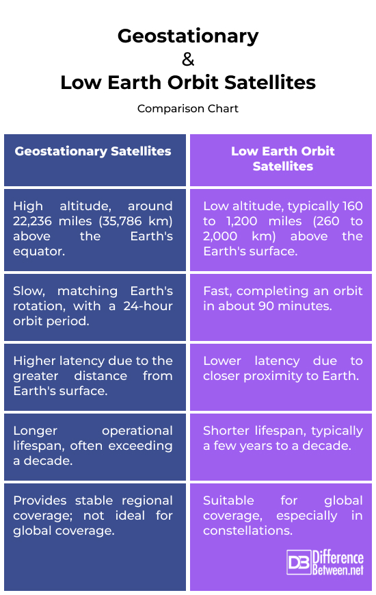
Geostationary satellites orbit the Earth at a much higher altitude, approximately 22,236 miles (35,786 kilometers) above the equator. LEO satellites, on the other hand, orbit at much lower altitudes, typically ranging from about 160 miles (260 kilometers) to 1,200 miles (2,000 kilometers) above the Earth’s surface.
Orbit Speed
GEO satellites have a slower orbital speed because they orbit at the same rate as the Earth’s rotation. This results in a 24-hour orbit period. LEO satellites move much faster due to their lower altitude, completing an orbit in roughly 90 minutes.
Latency
GEO satellites have higher latency because of their greater distance from the Earth’s surface. This can lead to noticeable delays in communication, which is not suitable for real-time applications. LEO satellites offer lower latency communication due to their closer proximity to the Earth. This makes them more suitable for applications requiring minimal delays, such as video calls and online gaming.
Lifespan
GEO satellites have a longer operational lifespan, often exceeding a decade or more, thanks to their stable orbits and lower exposure to atmospheric drag. LEO satellites have a shorter lifespan, typically ranging from a few years to a decade, as they experience greater atmospheric drag and must be replaced more frequently.
Global Coverage
GEO satellites can provide continuous coverage for a specific region, but they are not ideal for global coverage. They are commonly used for regional or continental services. LEO satellites are often deployed in large constellations, which work together to achieve global coverage. They are well-suited for global applications, such as providing internet access to remote and underserved areas.
Geostationary vs. Low Earth Orbit Satellites: Comparison Chart
Summary
In a nutshell, geostationary satellites offer stable regional coverage and are suitable for applications like broadcasting, while LEO satellites are known for low-latency global communication and applications like global internet services and Earth observation. GEO satellites orbit the Earth at a much higher altitude compared to LEO satellites. Geostationary satellites have a longer operational lifespan, often exceeding a decade, while LEO satellites have a shorter lifespan.
FAQs
Is a geostationary satellite a low earth orbit satellite?
No, geostationary satellites orbit at a high altitude above the equator and remain stationary relative to the Earth’s surface.
What types of satellites are in low earth orbit?
Low Earth orbit (LEO) is home to various types of satellites, including Earth observation satellites, communication satellites, scientific research satellites, and space stations like the International Space Station (ISS).
How can you tell if a satellite is in a geostationary orbit?
You can tell if a satellite is in a geostationary orbit by its altitude and location relative to the Earth’s equator. Geostationary satellites orbit at an altitude of approximately 22,236 miles (35,786 kilometers) above the equator and appear to stay fixed above a specific point on the Earth’s surface.
Are Starlink satellites geostationary?
No, Starlink satellites are not geostationary. Starlink, a project by SpaceX, deploys large constellations of LEO (Low Earth Orbit) satellites to provide global internet coverage.
Do geostationary satellites stay in one place?
Yes, geostationary satellites appear to stay in one place relative to the Earth’s surface.
Can geostationary satellites see all latitudes?
Geostationary satellites are positioned above the equator and have a fixed view of the Earth’s equator region. While they have a broad view of the equator and the areas near it, they have limited coverage of the polar regions.
- Difference Between Caucus and Primary - June 18, 2024
- Difference Between PPO and POS - May 30, 2024
- Difference Between RFID and NFC - May 28, 2024
Search DifferenceBetween.net :
Leave a Response
References :
[0]Pratt, Timothy, and Jeremy E. Allnutt. Satellite Communications. John Wiley and Sons, 2019.
[1]Zee, Chong-Hung. Theory of Geostationary Satellites. Springer Science and Business Media, 2013.
[2]May, Andrew. “Low Earth Orbit: Definition, Theory and Facts.” Space.com, 31 May 2022, www.space.com/low-earth-orbit.
[3]Image credit: https://www.canva.com/photos/MAE4IGrwskA-space-satellites-in-orbits-around-the-earth-globe-3d-rendering/
[4]Image credit: https://www.canva.com/photos/MADPjgVH-rI-space-satellite-communications-satellite-in-geostationary-orbit-of-planet-earth-elements-of-this-image-furnished-by-nasa/